Hiking Maps
All the hiking routes are currently closed due to the recent fire except for:
Wolfberg Cracks & Wolfberg Arch via the Cracks and Maltese Cross.
Lot’s Wife Short walk (short circular route/1.5km between Driehoek and Cederberg Wines).
Wolfberg Cracks & Wolfberg Arch via the Cracks and Maltese Cross.
Lot’s Wife Short walk (short circular route/1.5km between Driehoek and Cederberg Wines).
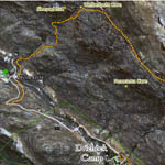
Driehoek Tourist Farm is situated in a valley in the heart of the Cederberg, at the foot of Tafelberg, 20 km from Algeria. The farm is well forested and water-rich, which together with the farm animals create a peaceful rural atmosphere. Driehoek is ideally situated as a base from which to hike to well known areas such as the Welbedacht Cave, Tafelberg, Wolfberg Arch, Sneeuberg and the Maltese Cross as represented on these 3D Maps below.
Cederberg Hiking Trail 1
From the farm to the upper
end of The Driehoek
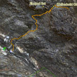
Cederberg Hiking Trail 2
From the Farm to the
Welbedacht Cave
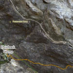
Cederberg Hiking Trail 3
From Eikeboom to the
Sneeuberg Hut
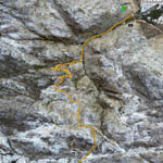
Cederberg Hiking Trail 4
From the Farm to the famous
Wolfberg Arch
Cederberg hiking Trail 5
Driehoek Circle Route